
abeMeda
The File Is Out There
 Deutsch

How abeMeda is used by Photographers
GeoFinder in abeMeda
abeMeda has the most extensive GPS (geotagging) integration available!
What are GPS or geocoding tags?
These are standard geographic locations, or GPS coordinates for photo files, and the process of adding these is called geotagging or geocoding.
Digital cameras always added information such as the F-Stop, exposure time, or the focal length into the EXIF data of the photo. Only lately are there a few cameras that also add the location where the shot was taken to the image.
With abeMeda, you can find photos taken near a location (GeoFinder), or display the GPS location of the photo in web services, such as Flickr, Panoramio, Google Maps, MapQuest, SmugMug, WikiMapia, Yahoo Maps, Geody, OpenStreet- Map, or Woophy.
abeMeda : the Geo Photo Manager
And abeMeda is also the only tool to catalog not only the coordinates, but also the optional additional GPS altitude, view direction, tilt, and distance information, captured by newer camera add-ons.
You can also add the valuable GPS information at any time to your existing photos, using utilities like the Panorado Flyer (www.panorado.com/en/PanoradoFlyer.htm) which also uses Google Earth to actually prepare the locations, or exiftool. But there are many more. You might want to check en.wikipedia.org/wiki/ Geocoded_photo for a starting point.
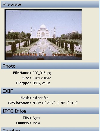
abeMeda will display the GPS data in the Inspector, in the EXIF (Photo Info) section (please look at the "GPS Location" field).
Built-in Geotagging
If your photos don’t have any geotags yet, you can also use abeMeda to tag them! abeMeda has built-in geotagging capabilities, that will take the current coordinates and viewpoint information from Google Earth and write them to the EXIF GPS information of your photos. abeMeda is one of the very few programs for Windows that will store the 3D-information like azimuth and tilt - that way you can actually see the sight of the original photo, not only see it from above !
Just select any photo on a catalog for an online volume, and choose Geotag from the GPS context menu. abeMeda will store the chose coordinates in the catalog, and also write it to the original file.
You might want to use some crosshairs like these to enhance your precision when pointing to the right coordinates.
Find all photos taken near that photo
The most amazing and unique ability of abeMeda allows you to display all photos that were taken in a certain distance near a selected
Photo (or any other place on earth, for that matter).
For that, select one photo you are interested in. Then, in the context menu for that photo file, select "All photos taken near...".
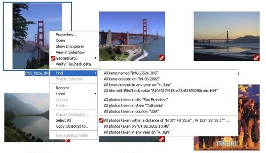
This will open the GeoFinder for you, with that location already
selected.
In the unique new GeoFinder, simply enter a distance, and start the
GeoFind:
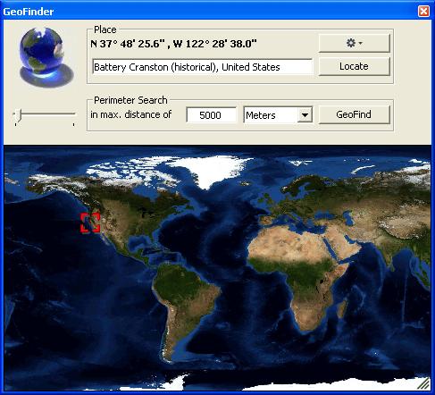
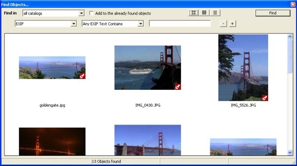
Afterwards, all photos within that distance of the original place
will
show up in the Found Items window.
Isn't that incredible?
Export as KMZ
Of course, you can use abeMeda to create a universal KMZ file with the GPS tags of one or multiple selected photos, and later use that in either Google Earth or any other KMZ enabled application.
Show in Google Earth
With abeMeda, you can let Google Earth 4 take you to the spot where that photo was taken. Just select the photo in abeMeda, and open the contextual menu for the item:
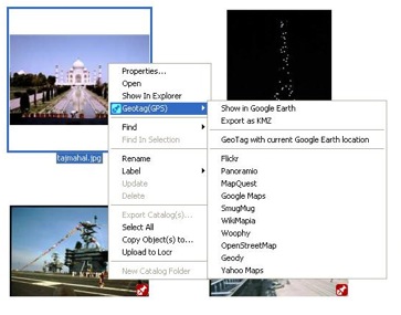
If you select "Show in Google Earth", abeMeda will ask that
application to display this location:
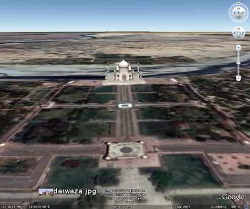
This requires Google Earth 4 or newer to be installed on your
computer.
Show the location of a photo on web services
With abeMeda, you can also display a GPS location in Flickr, Panoramio, Google Maps, MapQuest, SmugMug, WikiMapia, Yahoo Maps, Geody, OpenStreetMap, or Woophy. Just open the context menu for a photo (as shown above), and select Flickr or any of the other services.
If you have suggestions, just let us know!